Other lots by Hydrographic Office U.S. Navy
-
 #769Hydrographic Office U.S. Navy
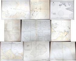
Een partij van 9 gedetailleerde nautische kaarten uit diverse jaren van de XXste eeuw. “Saint-Helena”. 2e Ed. 1924. “Marianas”. 9e Ed. 1921. “Pt. Arguello to San Isidro Pt”. 1e Ed. 1928. “North Coast of Brazil”. 4e Ed. 1939. “Marshal Islands Southern Part”. 1e Ed. 1924. “Booby Island to Albany Pass”. 2e Ed. 1927. “Anchorages in Aniwa Wan”. 1e Ed. 1924. “Bahia Honda”. 11e Ed. 1934. “Canal Chacao - Chile”. 1e Ed. 1924.
Un lot de cartes nautiques du XXième siècle, années différentes: “Saint-Helena”. 2e Ed. 1924. “Marianas”. 9e Ed. 1921. “Pt. Arguello to San Isidro Pt”. 1e Ed. 1928. “North Coast of Brazil”. 4e Ed. 1939. “Marshal Islands Southern Part”. 1e Ed. 1924. “Booby Island to Albany Pass”. 2e Ed. 1927. “Anchorages in Aniwa Wan”. 1e Ed. 1924. “Bahia Honda”. 11e Ed. 1934. “Canal Chacao - Chile”. 1e Ed. 1924.No longer availableEstimate: € 80 / 120 -
 #759Hydrographic Office U.S. Navy
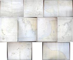
Een partij van 9 gedetailleerde nautische kaarten uit diverse jaren van de XXste eeuw. “New Guinea - North West Coast”. 2e Ed. 1927. “Ports between Timor & New Guinea”. Ed. 1925. “Marshall Islands, Central Part’. Ed. 1924. “Woodlark Island”. Ed. 1925. “Colombia, Santa Marta Bay”. Ed. 1921. “Dominican Republic, Monte Christi Bay”. Ed.1931. “Borneo, West Coast”. Ed. 1926. “Nova Scotia, South Coast. Cape Sable to Yarmouth”. 16e Ed. 1933. “North East Coast of Guiana. Orinoco river to Point Gorabal”.(..)
Un lot de neuf cartes nautiques, XXième siècle, années différentes: “New Guinea - North West Coast”. 2e Ed. 1927. “Ports between Timor & New Guinea”. Ed. 1925. “Marshall Islands, Central Part’. Ed. 1924. “Woodlark Island”. Ed. 1925. “Colombia, Santa Marta Bay”. Ed. 1921. “Dominican Republic, Monte Christi Bay”. Ed.1931. “Borneo, West Coast”. Ed. 1926. “Nova Scotia, South Coast. Cape Sable to Yarmouth”. 16e Ed. 1933. “North East Coast of Guiana. Orinoco river to Point Gorabal”. 42e Ed. 1939.(..)No longer availableEstimate: € 80 / 120
Other lots in this auction
-
 #759Hydrographic Office U.S. Navy
Een partij van 9 gedetailleerde nautische kaarten uit diverse jaren van de XXste eeuw. “New Guinea - North West Coast”. 2e Ed. 1927. “Ports between Timor & New Guinea”. Ed. 1925. “Marshall Islands, Central Part’. Ed. 1924. “Woodlark Island”. Ed. 1925. “Colombia, Santa Marta Bay”. Ed. 1921. “Dominican Republic, Monte Christi Bay”. Ed.1931. “Borneo, West Coast”. Ed. 1926. “Nova Scotia, South Coast. Cape Sable to Yarmouth”. 16e Ed. 1933. “North East Coast of Guiana. Orinoco river to Point Gorabal”.(..)
Un lot de neuf cartes nautiques, XXième siècle, années différentes: “New Guinea - North West Coast”. 2e Ed. 1927. “Ports between Timor & New Guinea”. Ed. 1925. “Marshall Islands, Central Part’. Ed. 1924. “Woodlark Island”. Ed. 1925. “Colombia, Santa Marta Bay”. Ed. 1921. “Dominican Republic, Monte Christi Bay”. Ed.1931. “Borneo, West Coast”. Ed. 1926. “Nova Scotia, South Coast. Cape Sable to Yarmouth”. 16e Ed. 1933. “North East Coast of Guiana. Orinoco river to Point Gorabal”. 42e Ed. 1939.(..)No longer availableEstimate: € 80 / 120 -
 #759Hydrographic Office U.S. Navy
Een partij van 9 gedetailleerde nautische kaarten uit diverse jaren van de XXste eeuw. “New Guinea - North West Coast”. 2e Ed. 1927. “Ports between Timor & New Guinea”. Ed. 1925. “Marshall Islands, Central Part’. Ed. 1924. “Woodlark Island”. Ed. 1925. “Colombia, Santa Marta Bay”. Ed. 1921. “Dominican Republic, Monte Christi Bay”. Ed.1931. “Borneo, West Coast”. Ed. 1926. “Nova Scotia, South Coast. Cape Sable to Yarmouth”. 16e Ed. 1933. “North East Coast of Guiana. Orinoco river to Point Gorabal”.(..)
Un lot de neuf cartes nautiques, XXième siècle, années différentes: “New Guinea - North West Coast”. 2e Ed. 1927. “Ports between Timor & New Guinea”. Ed. 1925. “Marshall Islands, Central Part’. Ed. 1924. “Woodlark Island”. Ed. 1925. “Colombia, Santa Marta Bay”. Ed. 1921. “Dominican Republic, Monte Christi Bay”. Ed.1931. “Borneo, West Coast”. Ed. 1926. “Nova Scotia, South Coast. Cape Sable to Yarmouth”. 16e Ed. 1933. “North East Coast of Guiana. Orinoco river to Point Gorabal”. 42e Ed. 1939.(..)No longer availableEstimate: € 80 / 120


